In the United States, ZIP codes are numerical codes used for postal purposes to efficiently sort and deliver mail. There are 41,704 ZIP Codes in the country and these codes range from representing specific buildings or businesses to encompassing entire cities or regions. It’s important to note that ZIP codes can change over time due to population shifts or administrative adjustments.
Brief Overview of the Zip Code System in the USA
The ZIP Code system in the United States, initially introduced in 1963, is an effective method used by the United States Postal Service (USPS) to manage mail delivery efficiently. Credited to be developed by Philadelphia Postal Inspector Robert Moon, ZIP codes were designed as a digit-based mail delivery system, which would help deal with the rising mail volume after World War II. Moon first proposed a three-digit system sending mail to regional hubs based on geography, later evolving into a five-digit system that includes local zones.
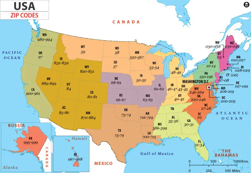
Currently, the United States has over 42,000 ZIP Codes, playing a crucial role in the nation’s mailing system. These five digits of a ZIP code are tied to the country’s geography, with each digit representing a specific area of the country. The first digit ranges from 0 to 9, while the next four digits offer further precision in defining one’s postal location within that region. Moreover, the introduction of the ZIP code system also required the standardization of state abbreviations, reducing each state name to two characters.
The subsequent addition of a four-digit extension to the ZIP code, known as ZIP+4, enabled the identification of smaller subareas within a ZIP code. This useful system now spans across the entire nation, linking territories and remote locations, making the process of mail delivery organized and efficient.
The Importance of Zip Codes in the USA
ZIP codes have an important role in the United States, primarily due to their utilization in various aspects of personal and business life. Here are some ways they make a significant impact:
- Efficient mail delivery: One of the primary reasons ZIP codes were introduced in 1963 was to improve mail sorting and delivery. Comprising of five digits, each number within the ZIP code signifies a specific region or state, allowing for efficient mail processing and faster delivery times.
- Geographical organization: ZIP codes provide a structured system of organizing addresses and understanding the country’s geography. The first digit represents a general area, such as a state or place within a state, while the remaining digits indicate specific areas and delivery points.
- Business applications: The combination of ZIP codes and census data allows businesses to pinpoint consumer demographics in specific areas. This targeted approach helps direct marketing firms and other businesses understand customer preferences and tailor their marketing campaigns accordingly.
- Streamlining communication: ZIP codes also make it easier for individuals and organizations to communicate with one another, especially when it comes to addressing mail. The standardized two-letter state abbreviations that were introduced alongside the ZIP codes help ensure that mail and packages are more accurately addressed and delivered.
- Symbol of identity: ZIP codes have become embedded in American culture and identity. For many people, their ZIP code symbolizes their neighborhood and the sense of belonging they have to a particular community.
Understanding the Structure of Zip Codes
The United States Postal Service (USPS) relies on a structured system of zip codes to efficiently deliver mail across the country. This system, introduced in the 1960s, is based on five digits that help narrow down the geographic location of the recipient.
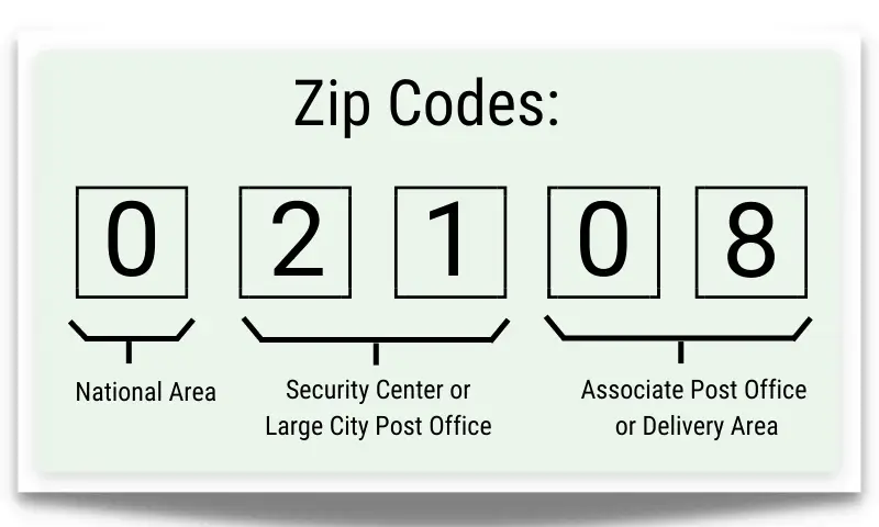
- To start, the very first digit of the zip code represents a general geographic area, ranging from 0 to 9. These digits correspond to different regions, like the Northeast, Southeast, or Midwestern United States. This helps sort mail at a broader level, ensuring that it reaches the correct region.
- Following the initial digit, there are two more digits that further narrow down the location within the region. These represent a Sectional Center Facility (SCF), which serves as a central mail processing hub for multiple post offices in its area. The combination of the first three digits identifies the SCF, streamlining the sorting process.
- The final two digits of the standard zip code help pinpoint the specific post office or zone within the SCF. This allows for more accurate delivery to the correct neighborhood or street.
- In 1983, USPS also introduced the ZIP+4 code system. This extends the standard five-digit zip code with four more digits, further refining the location of the recipient’s address. Mainly used for PO boxes, the extra digits ensure even better sorting and delivery accuracy.
Overall, the structure of zip codes is an organized and efficient way to handle mail delivery across the vast nation of the United States.
The Role of Zip Codes in Mail Delivery
The ZIP code, which stands for Zone Improvement Plan, has played a significant role in the mail delivery system in the United States since its introduction on July 1, 1963. As a part of the Postal Service’s Nationwide Improved Mail Service (NIMS) plan, the ZIP code aimed to improve the speed of mail delivery by utilizing a more mechanical and organized system.
Each ZIP code consists of five digits, with the first digit identifying one of the ten large areas of the nation, the second indicating a state or a geographic portion of a heavily populated state, and the third identifying a major destination area within a state or a Sectional Center. The final two digits indicate either a postal delivery unit of a large city post office or an individual post office served from a Sectional Center.
The introduction of ZIP codes led to a more efficient mail sorting process, with mail coded by ZIP being given priority delivery and reducing the number of times a mail item was handled. As the United States’ population and amount of mail increased, this system became a crucial element of the mail delivery process, helping to speed up processing and delivery times for both individual correspondence and bulk mail.
The Largest and Smallest Zip Codes in the USA
The United States is vast, and so are the ZIP codes. Interestingly, some of the largest and smallest ZIP codes in the country are not just based on their geographical size, but also on their population density. Here are some noteworthy largest and smallest ZIP codes in the USA.
- Alaska, unsurprisingly, boasts the largest ZIP code in terms of area. Spanning over 13,000 square miles, the 99557 ZIP code encompasses the rural areas around Aniak. On the other hand, the smallest ZIP code by area is 10018 in New York City. At a mere 0.01 square miles, it comprises only a few blocks of Manhattan’s Garment District.
- When considering population, California’s 90201 (Bell Gardens) holds the title of the most densely populated ZIP code. Home to over 100,000 residents within its 3.17 square-mile area, it boasts a density of more than 30,000 people per square mile. In contrast, the least densely populated ZIP code is 89049 in Nevada. Encompassing the remote Tokop region, it has a mere two residents within its 193 square-mile area.
Interestingly, The Village of Fishers Island in New York shares a ZIP code with Connecticut due to its unique location and for the convenience of mail delivery. It is assigned the 06390 ZIP code, unusually being the only New York ZIP code beginning with “0”.
Conclusion
In conclusion, ZIP Codes play a significant role in American businesses and lives. As a vital element of the demographics, they have evolved from being just a geographical unit to becoming an indispensable tool in marketing. They enable direct marketing firms to better target their audiences by using the 5-digit ZIP code to pinpoint consumer tastes and lifestyles based on their location.
The ZIP code, which stands for Zone Improvement Plan, was introduced on July 1, 1963, as a part of the Postal Service Nationwide Improved Mail Service (NIMS) plan to expedite mail delivery. Each digit within the ZIP code represents certain geographical aspects, helping to streamline the sorting and processing of mail, thus reducing delivery times. Back then, adopting the ZIP code system took time, but eventually, it became the norm, and mail with ZIP codes started receiving priority in terms of delivery times.
References:
https://facts.usps.com/42000-zip-codes/
https://www.unitedstatesnow.org/how-many-zip-codes-are-in-the-united-states.htm